© 2024 Public Radio East
Public Radio For Eastern North Carolina 89.3 WTEB New Bern 88.5 WZNB New Bern 91.5 WBJD Atlantic Beach 90.3 WKNS Kinston 88.5 WHYC Swan Quarter 89.9 W210CF Greenville
Play Live Radio
Next Up:
0:00
0:00
0:00 0:00
Available On Air Stations

Hurricane Franklin churning up the surf in ENC; Hurricane Idalia could bring heavy rain

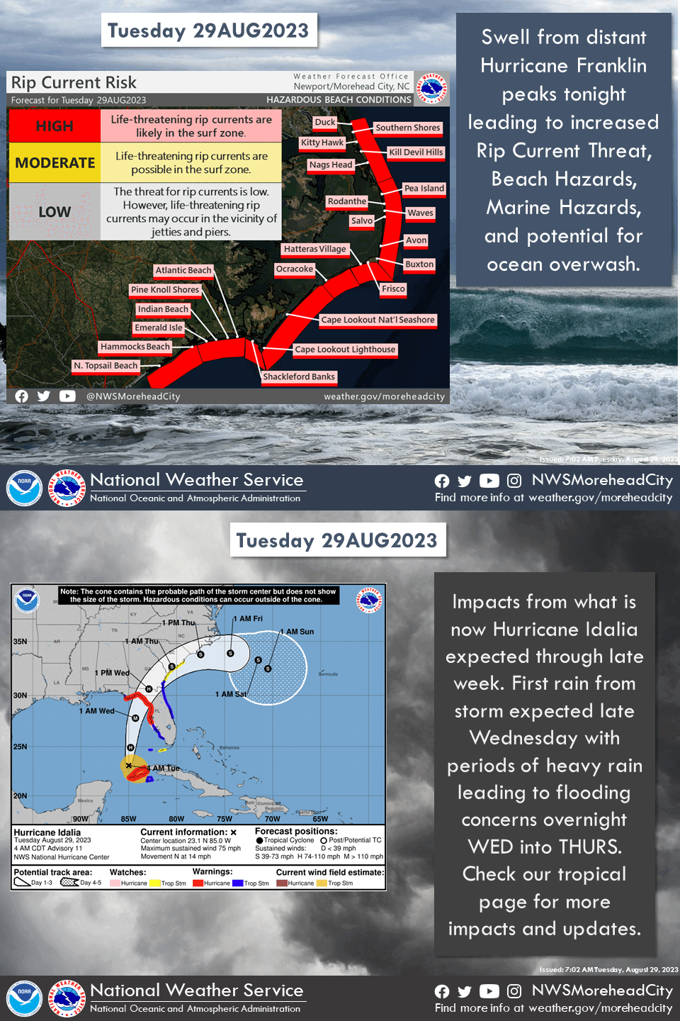
Although it will remain well off the eastern North Carolina coast, forecasters with the National Weather Service in Newport said Hurricane Franklin will impact the area beginning Tuesday with dangerously high surf, strong rip currents, and possibly coastal erosion.
The National Weather Service in Newport/Morehead City
/
weather.gov
Although it will remain well off the eastern North Carolina coast, forecasters with the National Weather Service in Newport said Hurricane Franklin will impact the area beginning Tuesday with dangerously high surf, strong rip currents, and possibly coastal erosion.

The National Weather Service in Newport is cautioning people that two storm systems could have a big impact on the area’s coastal communities this week.

Meteorologist Rohan Jain said although it will remain well off the eastern North Carolina coast, Hurricane Franklin will impact the area beginning Tuesday with dangerously high surf, strong rip currents, and possibly coastal erosion.

“It’s going to curve out into the north Atlantic, so we’re not anywhere near that path but there are those beach and coastal hazards expected through mid-week and maybe even end week, depending on the track of Idalia,” he said.

Because eastern North Carolina is in a king tide period, the impact will be a bit greater. Jain said, “With king tides, water levels are higher than normal, co any rainfall or higher waves will have a compounding effect on that.”

A King Tide is a popular, non-scientific term people often use to describe exceptionally high tides that happen during a new or full moon.

Meanwhile, Jain said Hurricane Idalia is expected to make landfall in Florida Wednesday morning, “And then its going to track northeastward toward eastern North Carolina. It’s expected to weaken as it approaches us, into the tropical storm/tropical depression category.”

He said the track and the amount of rain in ENC from the storm could change after Idalia makes landfall in the U.S., so they’ll be keeping a close eye on that over the next few days.

A high surf advisory remains in effect for eastern North Carolina until 8 a.m. on Wednesday, with dangerous rip currents and large breaking waves expected.

The weather service says localized ocean overwash will be possible between Oregon Inlet and Cape Lookout.

There is also a small craft advisory in effect until 2 a.m. Thursday.

Annette is originally a Midwest gal, born and raised in Michigan, but with career stops in many surrounding states, the Pacific Northwest, and various parts of the southeast. An award-winning journalist and mother of four, Annette moved to eastern North Carolina in 2019 to be closer to family – in particular, her two young grandchildren. It’s possible that a -27 day with a -68 windchill in Minnesota may have also played a role in that decision. In her spare time, Annette does a lot of kiddo cuddling, reading, and producing the coolest Halloween costumes anyone has ever seen. She has also worked as a diversity and inclusion facilitator serving school districts and large corporations. It’s the people that make this beautiful area special, and she wants to share those stories that touch the hearts of others. If you have a story idea to share, please reach out by email to westona@cravencc.edu.